Sounding of the Sea or Lake Beds
GTK’s sounding surveys investigate the geological structure of areas covered by water. Research results assist in the planning of the construction on the seabed or lake bed and in the analysis of the environmental conditions and the quantification of the extractive materials of the watercourse.
A variety of geophysical methods used in surveys
Boosting implementation of infrastructure projects
Finland’s most comprehensive sounding survey service
Knowledge about the structure of seabeds and lake beds is central to many activities
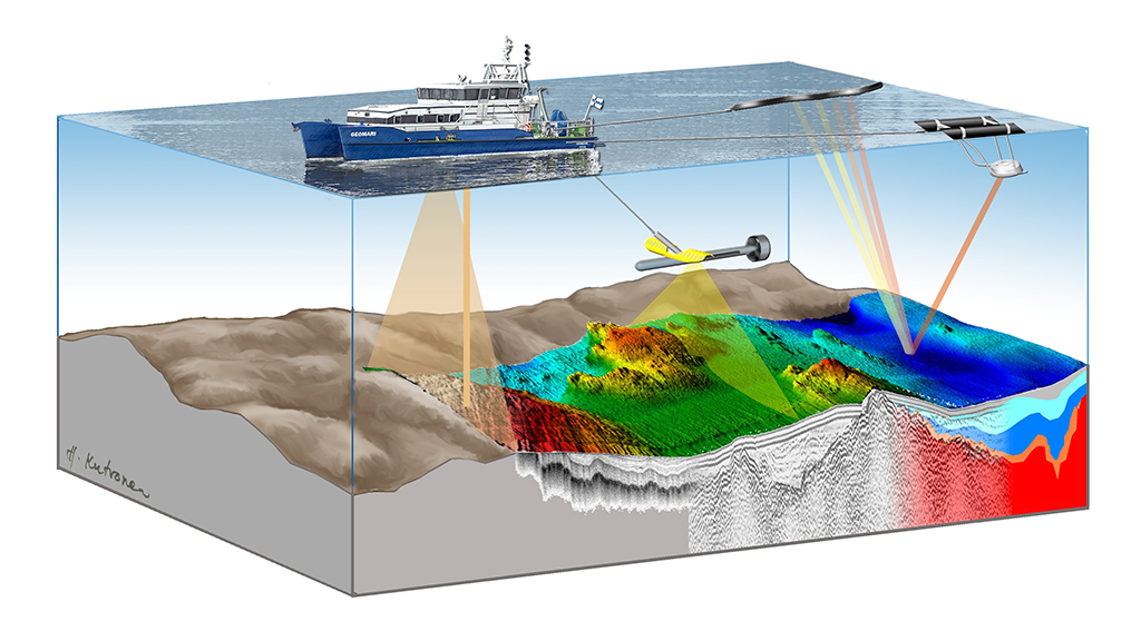
Sounding surveys are used to investigate the quality, thickness, and structure of seabed or lake bed sediments. GTK’s service enables several simultaneous high- and low-frequency sub-bottom soundings. The applied methods include CHIRP sub-bottom profiling, multibeam sonar surveys, side-scan sonar surveys at different frequencies, and low-frequency sub-bottom profiling of coarse sediments and bedrock surface (Sparker, Boomer).
A sounding survey of a water-covered area provides information about the suitability of the target site for construction.
GTK’s survey of the geological structure of a water-covered area includes the following
- sounding surveys, sediment sampling, and analysis services
- stratigraphic / sediment unit interpretation
- sediment investigations
- seabed or lake bed substrate map
The service provides research results to be used in activities such as the planning of underwater construction, extractive material surveys, and the investigation of the environmental conditions of the seabed or lake bed. Geophysical surveys can also be used to study groundwater resources underlying water-covered areas.
Sounding surveys in development of offshore wind power
Surveys of the geological structure of the seabed are needed as a knowledge base for the planning of offshore wind power and seabed construction.
Sounding surveys in management of dredging and dumping of material
Structural surveys of the bottom of water-covered areas support the management of dredging and dumping of material during construction, as well as the overall management of limited extractive material resources. The service may also include contaminant investigations and studies related to mass stabilisation.
Research on the topic
Explore the topic in depth through scientific publications, articles, research reports, and research projects.
Contact us
Leave your contact information and we will get back to you.