First Spatial Dataset on Peatlands Covers Mires and Drained Peatlands Throughout Finland
Finland’s first nationwide open spatial dataset on peatland site types, fertility status categories and land use in peatlands is now a reality. The information accuracy of data previously collected on peatland vegetation and soils was improved by combining remote sensing data with machine learning. The resulting peatland site type dataset is exceptionally comprehensive, particularly in terms of the scope and content of the data. The database facilitates the assessment of greenhouse gas emissions from peatlands and pollutant loads in water bodies, and it is a useful tool for forestry planning and protection of endangered mires.

In Finland, data on different soil properties has been collected in a decentralised manner into several databases by different organisations. As a result, some of the available soil data has been left unused, or it has not been applied in their full potential. In particular, the limited amount of soil data has posed restrictions on the planning of agricultural and forestry activities. In the future, one of the preconditions for receiving forestry subsidies will be the planning of peatland management at landscape scale, which will require more comprehensive information on the properties of different peatland site types.
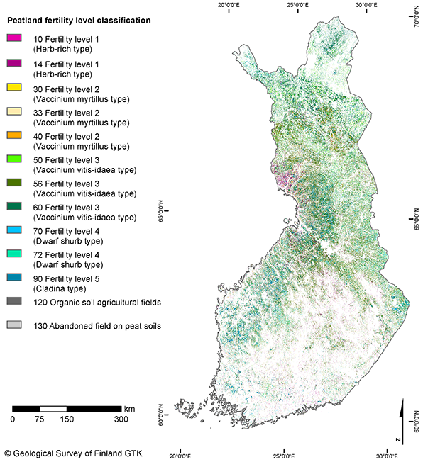
This peatland site type dataset, produced in the Advances in Soil Information project (Maaperätiedon kehittäminen, MaaTi) funded by the Ministry of Agriculture and Forestry of Finland, is aimed at improving the information accuracy of national geospatial datasets in terms of peatland site type, fertility status and land use (forestry drained peatlands, agricultural fields on organic soils, and peat production areas).
The data can be used to classify all Finnish peatlands into the above-mentioned categories at pixel size of 10×10 metres. Similar open spatial datasets covering all peatlands have never been available before. The total surface area of peatlands in Finland (approx. 9 million hectares) incudes undrained mires, forestry drained peatlands, agricultural fields on organic soils and peat production areas. Approximately half of the total peatland area consists of drained peatlands (4.7 million hectares).
“Never before have we had a nationwide, consistent, and uniformly produced spatial dataset with this kind of information content. Similar data has existed in several databases as point-wise observations or covering smaller areas. Our goal was to produce new spatially continuous information based on these existing data. Moreover, the peatland site type dataset was produced with a new approach which utilises remote sensing data from various sources, field observations, and machine learning methods,” says Associate Research Professor Maarit Middleton from the Geological Survey of Finland (GTK).
Furthermore, this peatland site type dataset, covering all of the Finnish peatlands, is presumably the first of its kind even by international standards.
Superior predictability of mire types
When the peatland site type dataset was compiled, various machine learning models were tested to predict the existence of specific peatland site types with the help of remote sensing data. In practice, the so-called teaching material for the machine learning process consisted of all essential, openly available spatial and remote sensing data. The quantity of the processed data was so massive that the computing resources of CSC – IT Center for Science’s supercomputer were required.
The used remote sensing data consisted of optical and radar satellite data, digital elevation and vegetation surface models, and data of multi-source national forest inventories and aerial geophysical programmes. The modelling process included a feature selection step, which was used to discover optimal explanatory factors from the data to predict the occurrence of undrained and drained mires. The peatland site types are based on two gradients, namely the fertility and water content. The dataset comprises 40 different peatland site types and seven fertility status categories, making it an exceptionally comprehensive classification system compared to any other peatland-related spatial datasets generated with the help of remote sensing.
According to Sakari Tuominen, Senior Scientist at the Natural Resources Institute Finland, the reliability of the data seems promising, especially when looking at it in regional scale and in terms of the fertility categories. “It is a typical of most data produced with remote sensing and machine learning that when we use smaller units, the predictions become more uncertain. When the unit cell is as small as an individual pixel, the level of uncertainty in the map data becomes rather substantial. On the other hand, based on the test data, the results for larger areas are fairly accurate. Moreover, the use of machine learning methods in predicting the more uncommon classes tend to be difficult due to the small number of observations. However, the data may be suitable as baseline material for identifying and assessing the silvicultural practices of peatland forests, for example,” Tuominen says.
Users of the peatland site type dataset are advised to carefully familiarise themselves with the metadata and quality measures delivered with the dataset. The uncertainty of the data varies by classification and also regionally, as certain input materials were not available everywhere. In addition to the peatland site type dataset, a technical report has been published with more detailed information on how the data was produced.
Keeping any dataset up to date is a widely recognised challenge. Even now, efforts such as restoration measures are causing rapid changes in peatlands. Updating the peatland site type dataset would require access to the latest field observation and remote sensing data, but the availability of said data is challenging. However, the development of remote sensing and machine learning methods can improve the situation in the future.

Further information
Peatland site type dataset in GTK`s Hakku online service
Peatland site type dataset in GTK`s Map service of mires and peatlands (in Finnish)
Maarit Middleton, Associate Research Professor
Geological Survey of Finland GTK
tel. +358 29 503 4345
maarit.middleton@gtk.fi
Sakari Tuominen, Senior Scientist
Natural Resources Institute Finland (Luke)
tel. +358 29 532 2167
sakari.tuominen@luke.fi
Raisa Mäkipää, Research Professor and MaaTi project coordinator
Natural Resources Institute Finland (Luke)
tel. +358 29 532 2197
raisa.makipaa@luke.fi
The Advances in Soil Information (MaaTi) project is part of the Catch the Carbon climate action programme launched by the Ministry of Agriculture and Forestry of Finland in spring 2020, which aims to reduce the greenhouse gas emissions from agriculture, forestry and other land use and to strengthen carbon sinks and storages. The project was implemented by the leading partner Natural Resources Institute Finland in collaboration with the Geological Survey of Finland, the University of Helsinki, and the University of Turku.

