Science Blog: Using the 50 Hz EM method to locate conductive mineralizations in electro-magnetic well-logging
The two-year Dynamic Control of Underground Mining Operations project (DynaMine) was carried out in 2014-2015. In the Green Mining project, VTT Technical Research Centre of Finland, Aalto University and the Geological Survey of Finland (GTK) participated in research cooperation with mining companies, with the goal of optimising extraction planning and mine safety.
As part of a joint project of dynamic control of mining, GTK developed a monitoring system for the electrical conductivity of rock using the electrical infrastructure of the active mining environment (e.g. its 50 Hz power grid, elevators and machinery). This method is based on electromagnetic induction, and it works in environments where the object’s conductivity is higher than that of the adjoining rock. According to Faraday’s law, an electromotive force is induced in a closed loop when a variable magnetic field passes through the loop, and the magnitude of the force is equal to the rate of change of the magnetic field passing through the loop (dB/dt). According to the same principle, electric currents are induced in an object in the Earth’s crust when a variable magnetic field passes through the object. The currents generated in the object generate a secondary magnetic field. According to Faraday, an electromotive force tends to generate an electric current in a wire loop that generates a magnetic field within the loop cancelling out the change in the external magnetic field.
The effect of the secondary field can be measured, for example, from the ground or from a deep drill hole in the rock. When the electric current is not switched off during the measuring, the secondary field sums up with the transmitter’s (e.g. power lines) primary field, and the total field is measured. The measuring system developed by GTK measures for changes in the total field in the drill hole. If the transmitter’s power is switched on and off in the right way, the secondary field generated in the conductor can be measured. The generated secondary field is proportional to the object’s electrical conductivity. Changes in the electrical conductivity are used to determine the object’s boundaries and occurrence, as well as possible changes caused by the progressing extraction. The method is suitable for vastly different mining environments around the world.
The method makes use of the electromagnetic noise generated by continuous use of electricity. As with other electromagnetic fields, the 50 Hz noise of the power grid induces electrical currents to all conductors, which generate a new local electromagnetic field around them. The phenomenon has been observed in earlier mineral exploration research, but it has not been made use of. Typically, we try to get rid the 50 Hz noise by all possible means. However, in a mining environment, the otherwise detrimental electromagnetic noise is a practical and far-reaching excitation signal. The mining environment is an excellent research subject for this phenomenon, as mines use a lot of electricity.
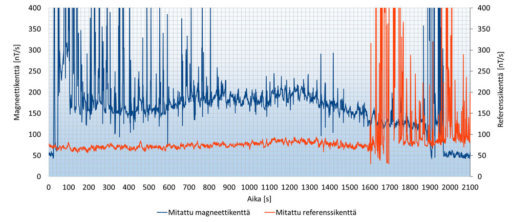
GTK had access to an almost perfect set of measuring instruments, because the method had already been tested successfully at the Pyhäsalmi mine. The most essential equipment requirement was the building of a new measuring sensor, which could be used to monitor changes in the levels of the total electromagnetic field generated by the electromagnetic noise in drill holes. The device was fitted with three induction coils in order to measure all three components (x, y and z) of the total magnetic field. When the measuring starts, the drill hole device is lowered to the bottom of the drill hole and is left to stabilise. Then the device takes measurements for a specified time. The device works as a data recorder, as it is not electronically connected to any surface unit. In other words, the device is not monitored during the measuring. At each measuring point (approx. 10 metre intervals), the drill hole device remains stationary for a specified time and continues to take measurements for the whole duration. When measurements have been taken at all measuring points, the device is removed from the hole. According to induction theory, the voltage induced in an object is proportional to the time-derivative (dB/dt) of the magnetic field passing through the object, so when measuring the voltage generated in the calibrated coils of the device, the voltage values can be converted to nanoteslas per second (nT/s) that correspond to magnetic field time derivative values. In the processing phase, the measured time frame’s magnetic data (Resultant dB/dt field vs. second, Figure 1) is converted to a frequency range (Resultant dB/dt field (reference) vs. frequency, Figure 2) with Fourier transformation, and the result for 50 Hz is picked from the results.

The drill hole measurements were carried out at the Pyhäsalmi mine using several deep holes drilled from the surface as well as a few holes drilled inside the mine. The results were good, and it was possible to confirm the conductive deposits identified in earlier measurements also with the new method. Anomalies were identified through local variations in the amplitude of the magnetic field in the drill holes. In addition, comparing the measured magnetic data with data from other electromagnetic measurements in the area, the benefits and accuracy of the method can be evaluated. Usually, controlled sources are used in electromagnetic measurements, so the distance from and direction of the transmitter are known. In addition, the position of the transmitter can be changed, thus ensuring efficient and sufficient engagement of the transmitter with the subject, which makes it possible to refine the position estimation. When using power lines as sources, the position of the transmitter cannot be changed, which makes it more difficult to estimate the location of the object in the bedrock.
The main sulphide zone (MSZ) outside of the Pyhäsalmi main deposit runs from northeast to southwest. It is an iron and magnetic pyrite-bearing deposit, which sinks to the southwest.
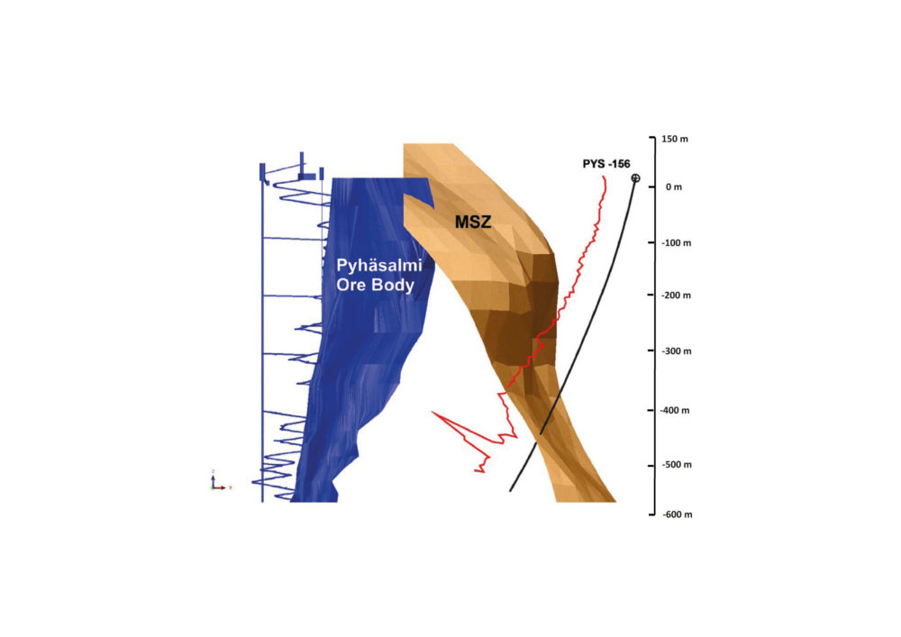
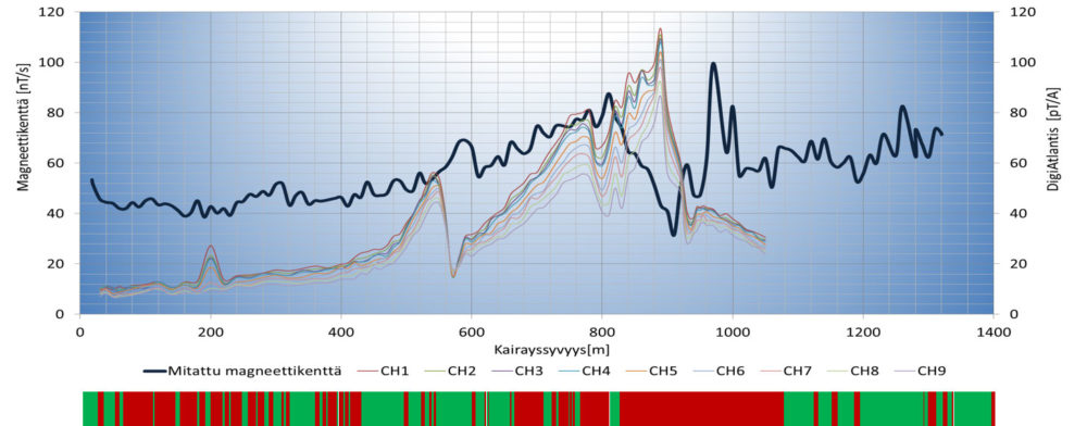
The amplitude of the magnetic field increases as expected when approaching the main sulphide zone (red line). The point of intersection contains scattered iron and magnetic pyrite, as well as occasional sulphide veins (Figure 3). Drill hole PYS-156 also had a DigiAtlantis measurement result (CH1-CH9). The effect of the main sulphide zone is consistent with both the electromagnetic measurement (dark blue line) and the DigiAtlantis (coloured lines) results (Resultant B field) at the depth range of 540-560 metres (Figure 4). Drill hole PYS-156 intersects the main sulphide zone at the depth range of 800-1000 metres, which can clearly be seen in the electromagnetic measurement result (Resultant dB/dt field). The same amplitude variation can also be seen in the DigiAtlantis results. All in all, the results of both methods are very similar.

In the project we were able to establish that magnetic fields generated by, for example, 50 Hz power lines can be utilized to locate conductive mineral deposits by electromagnetic measurements made in deep rock drill holes. Originally, these sources were not designed for mineral measurements, and the effect of the 50 Hz frequency needs to be removed from the measurements using a frequency other than 50 Hz or its harmonic frequencies. Although the interpretation of measured electromagnetic drill hole data is more difficult than the interpretation of data from controlled sources, conductive mineral deposits can still be identified based on the measured magnetic amplitude variations.
The measurements are simple, and the method can be used among the first methods in a new drill hole. Especially when the drill hole intersects a conductive object or the object is near the drill hole, the object is easy to identify. Amplitude variation can also give a rough estimate of the local extent of the mineral deposit.
An article about this subject can be read in its entirety at:
https://doi.org/10.1080/08123985.2019.1600300.
Arto Korpisalo and Esa Pohjolainen
Arto Korpisalo received his MSc (1996) in medical physics from Kuopio Korkeakoulu (Finland) and PhD (2016) in physics from Helsinki University. He has worked since 1997 in Geological Survey of Finland (GTK) as a physicist. His research interests include forward and inverse problems in drillhole thermophysics and electromagnetism.
Senior Specialist Mr. Esa Pohjolainen has been working for the Geological Survey of Finland (GTK) since 2008. The focus of his work has been on mineral exploration projects both in Finland and overseas.